Before Turn-by-Turn Directions: How Travellers Carried Their Routes
Learn how paper maps, route notes, and printed directions helped travelers understand a journey’s shape, notice useful landmarks, and adapt when plans changed.
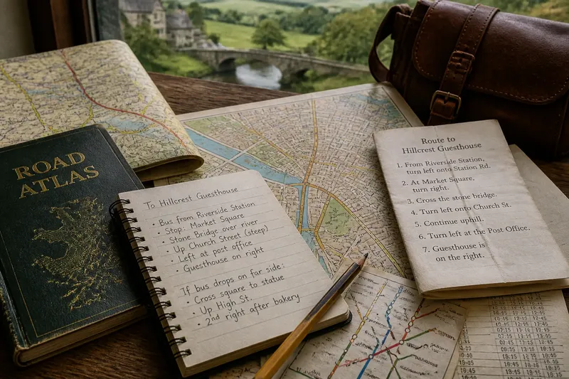
The common mistake with an unfamiliar route is to treat directions as a string of commands: turn here, continue there, arrive. Before a phone could announce each maneuver, travelers carried paper maps, handwritten notes, and printed directions that made the route visible as a whole. These tools asked for more attention, but they also showed how one place connected to another—and where a traveler might need to improvise.
What did a route guide need to do?
A route guide had two jobs. It had to help someone reach a destination, and it had to help them recognize where they were along the way. The first job called for usable instructions; the second called for context.
A road atlas might show a city as a dense tangle of streets, a highway map as a line between regions, and a local map as a web of bridges, parks, and neighborhoods. Each view answered a different question. The traveler choosing a map needed to know whether the task was crossing a state, finding a station, or locating a street after leaving the station.
Scale mattered because no single sheet could show everything clearly. A broad map revealed the route’s direction and neighboring towns, while a detailed city plan made individual junctions legible. Travelers often combined them: one map for the long approach, another for the final stretch.
That combination was not redundant. It kept a local turn from swallowing the larger journey. A detour might look confusing at street level but sensible when seen against a river crossing or the next town.
How did paper maps make a journey easier to understand?
A paper map put several possible routes in view at once. A traveler could compare a direct road with a slower route through a market town, notice that a highway followed a valley, or see that a ferry connected two stretches of coast. The map did not choose; it made the choice visible.
Its symbols required interpretation. A blue line might indicate water, a colored line a major road, and a small mark a station or landmark. The legend supplied the meaning. Learning to read that key turned the page from a picture into a working model of the area.
Maps also showed relationships that a list of turns could hide. A destination might lie beyond a ridge, beside a canal, or just across a rail line. Those features gave travelers clues about the landscape and helped them check whether their progress made sense.
There was a practical limit: a printed map could be out of date, folded over the relevant street, or too broad to resolve a tricky junction. It was a guide to geography, not a live report on closures or current conditions. A traveler still had to observe the road and read signs.
Why write route notes instead of copying every turn?
Route notes distilled a map into reminders that mattered at decision points. Rather than transcribing every street, a traveler might write the name of a bridge, the town where a main road changed, or the side of a station where the bus stop stood. These details were easier to scan than a dense page while standing at a junction.
Good notes described what could be recognized. “After the stone bridge, follow signs for the old center” gave a visible cue and a next action. “Continue for a while” offered neither. A useful note could also preserve an alternative: if the river road was closed, take the signed route through the next town.
Notes worked best when they stayed selective. Too much copied detail made the page another map, only harder to check. A few names, transitions, and landmarks could hold the route together without pretending to describe every moment.
Say you are traveling from a rural station to a guesthouse in a nearby town. You jot down the bus stop name, the bridge beside the river, and the street that leads uphill from the square. If the bus drops you on the far side of the square, those cues let you recognize the area and adjust rather than search for a memorized sequence of turns.
What did printed directions add to maps?
Printed directions converted a route into a sequence that could be followed without interpreting every line on a map. They were useful for drivers, visitors arriving late, or anyone who needed to share a clear plan with another traveler. A page might name the road, identify a junction, and specify which direction to take.
Their weakness was the same as their strength: they focused on one proposed path. If a road was blocked or a turn had been missed, the remaining instructions could become confusing. A map offered room to recover; printed directions offered a simpler path when conditions matched the description.
That is why travelers paired the two. Directions could handle the busy sequence through a city, while a map showed nearby alternatives and the destination’s position. The page did not need to be perfect to be useful; it needed enough context to help the traveler decide what to do when a cue did not match.
How did travellers check their position without a moving dot?
They compared clues. A road sign, river, station name, street pattern, or visible landmark could confirm—or challenge—their sense of location. On a map, travelers might trace the route with a finger and look for the next named place. On foot, they could match a street sign to the map’s labels.
This was a form of orientation, not just navigation. Orientation means understanding which way is which and how nearby places relate; navigation means choosing a path to a destination. The two overlap, but they are not identical. Someone can know they are beside the river and still need to decide which bridge to cross.
Pausing to check was part of the method. A traveler could step out of a doorway, unfold a map away from a curb, and compare the street layout before continuing. That pause replaced the silent correction a phone might make with an intentional check.
Which paper route tool suits which journey?
- Road atlas: Useful for seeing connections between towns and comparing broad driving routes.
- City street map: Better for locating neighborhoods, transit stops, and nearby streets.
- Handwritten route notes: Helpful for landmarks, changes between transport modes, and personal reminders.
- Printed directions: Convenient for a specific route with a clear sequence of roads or turns.
- Transit map or timetable: Useful when the journey depends on stations, lines, transfers, or service patterns.
Use the format that answers the question in front of you. A timetable explains when a service is due; a transit map explains where its line goes. Neither necessarily shows the last walk to a lodging or entrance, so a small street map may fill that gap.
For current service, access, and road information, check the relevant operator or local authority. Map conventions and available updates vary by place.
How can travellers read old route tools today?
Paper tools remain useful even when a phone handles routine directions. A folded regional map can show the shape of a day trip at a glance; a few written cues can preserve the names of transfer points; and a printed plan can offer a readable backup when a screen is difficult to consult.
To make them practical, mark only what supports a decision. Circle the destination, note a likely transfer, and identify a recognizable landmark near the final approach. Keep the map’s scale in mind: a mark that looks close on a regional sheet may still be a substantial walk.
For a route with several modes, separate the transitions. Note where a train ride ends, which exit or street leads onward, and what feature confirms arrival in the right neighborhood. This helps prevent a correct first leg from becoming a confusing second one.
What do readers still ask about paper directions?
Are paper maps still useful if a phone is available?
Yes, especially for seeing a region or comparing alternate roads at once. A paper map can also provide context when a phone’s directions focus only on the next maneuver.
What should route notes include?
Write down names and cues that mark a decision: a station, bridge, road change, or recognizable square. Keep the notes brief enough to check quickly, and include an alternative only when it is genuinely useful.
Are printed directions better than a map?
They are easier to follow when the route is straightforward and the listed turns match the conditions. A map is more helpful for seeing nearby options or recovering after a missed turn, so the two can complement each other.
How can I tell whether I am on the right route?
Compare more than one clue, such as a road sign and a river crossing, with the map or notes. If the clues disagree, pause somewhere safe and reorient before choosing the next turn.
Why did carrying a route change the experience?
A paper map, a few route notes, and printed directions made travelers active interpreters of the journey. They had to connect signs, landmarks, and choices, then revise their understanding when the view changed. That effort could make a place feel less like a sequence of instructions and more like a landscape with relationships.
The lasting lesson is not that paper is always better. It is that a route becomes easier to adapt when you can see more than the next turn. Before setting out, note one landmark beyond the destination approach; that small piece of context can help you recognize where you are, not merely where the directions say to go.